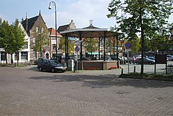
IJzendijke
IJzendijke | |
|---|---|
Small city | |
 IJzendijke - the market | |
| Coordinates: 51°19′17″N 3°36′59″E / 51.32139°N 3.61639°E | |
| Country | Netherlands |
| Province | Zeeland |
| Municipality | Sluis |
| Area | |
| • Total | 47.08 km2 (18.18 sq mi) |
| Elevation | 2.2 m (7.2 ft) |
| Population (2021)[1] | |
| • Total | 2,400 |
| • Density | 51/km2 (130/sq mi) |
| Time zone | UTC+1 (CET) |
| • Summer (DST) | UTC+2 (CEST) |
| Postal code | 4515[1] |
| Dialing code | 0117 |

IJzendijke is a city in the municipality of Sluis, about 10 km east of Oostburg, in the Dutch province of Zeeland.
The town received city rights in 1303.
History
[edit]The town was first mentioned in 1127 as Isendica, and means "dike of Iso (person)".[3] IJzendijke used to be a possession of the Saint Peter's Abbey in Ghent. In 1127, it joined the Flemish Hanseatic League.[4] In 1303, it received city rights. It was flooded in 1374,[5] and lost completely in the St. Elizabeth's flood of 1404.[4]
In 1587, a sconce was constructed by the Spanish troops, and conquered by Maurice, Prince of Orange in 1604. Two polders were constructed, and after 1618, an octagon fortress was built with a central market square. In 1648, IJzendijke became a garrison city.[4]
The Dutch Reformed church is an aisleless church built between 1612 and 1614. Between 1656 and 1659, it was enlarged to a stretched octagon. The war damage was repaired in 1949.[4]
Even though the fortress was deemed unconquerable, Napoleon managed to take the city.[5] IJzendijk was home to 2,068 people in 1840.[6] The fortification were demolished between 1841 and 1843 except for a western part.[4]
The southern part of the IJzendijke was severely damaged in 1944.[4] IJzendijke was a separate municipality until 1970. Prior to 2003, the town was in the municipality of Oostburg.[7] In 2003, it became part of the municipality of Sluis.[6]
Gallery
[edit]-
Central square
-
Reformed church
-
Church: de Onze Lieve Vrouwe ten Hemelopnemingskerk
-
Windmill: de Witte Juffer
-
Museum
References
[edit]- ^ a b c "Kerncijfers wijken en buurten 2021". Central Bureau of Statistics. Retrieved 21 April 2022.
- ^ "Postcodetool for 4515AA". Actueel Hoogtebestand Nederland (in Dutch). Het Waterschapshuis. Archived from the original on 21 September 2013. Retrieved 21 April 2022.
- ^ "IJzendijke - (geografische naam)". Etymologiebank (in Dutch). Retrieved 21 April 2022.
- ^ a b c d e f Piet van Cruyningen & Ronald Stenvert (2003). IJzendijke (in Dutch). Zwolle: Waanders. ISBN 90 400 8830 6. Retrieved 21 April 2022.
- ^ a b "IJzendijke". Mooiste Dorpjes (in Dutch). Retrieved 21 April 2022.
- ^ a b "IJzendijke". Plaatsengids (in Dutch). Archived from the original on 30 May 2024. Retrieved 21 April 2022.
- ^ Ad van der Meer and Onno Boonstra, Repertorium van Nederlandse gemeenten, KNAW, 2011.


