Menai, New South Wales
| Menai Sydney, New South Wales | |||||||||||||||
|---|---|---|---|---|---|---|---|---|---|---|---|---|---|---|---|
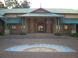
 Menai community buildings | |||||||||||||||
 | |||||||||||||||
| Population | 10,419 (2021 census)[1] | ||||||||||||||
| Established | 1973 | ||||||||||||||
| Postcode(s) | 2234 | ||||||||||||||
| Elevation | 116 m (381 ft) | ||||||||||||||
| Location | 28 km (17 mi) south of Sydney CBD | ||||||||||||||
| LGA(s) | Sutherland Shire | ||||||||||||||
| State electorate(s) | |||||||||||||||
| Federal division(s) | Hughes | ||||||||||||||
| |||||||||||||||
Menai is a suburb in southern Sydney, in the state of New South Wales, Australia 29 kilometres south of the Sydney central business district in the local government area of the Sutherland Shire.
History
[edit]Menai is named after Menai Bridge, a town on the Menai Strait in Wales.
The area now known as Menai was originally called Bangor in 1895 by the land's owner, a farmer named Owen Jones, after his birthplace Bangor in Wales. To avoid confusion with Bangor in Tasmania, the Postmaster General's Office changed the suburb name to Menai in 1910. Menai Bridge in Wales lies opposite Bangor on the Menai Strait. When Menai expanded, the eastern section became Bangor again.[2]
The suburb has been affected by bushfires on several occasions, including the 1994 Eastern seaboard fires and 2017–18 Australian bushfire season.
Population
[edit]According to the 2021 census of Population, there were 10,419 people in Menai.
- Aboriginal and Torres Strait Islander people made up 1.3% of the population.
- 78.6% of people were born in Australia. The next most common countries of birth were England 2.5%, China 1.4%, South Africa 1.2%, New Zealand 1.1% and North Macedonia 0.9%.
- 80.4% of people spoke only English at home. Other languages spoken at home included Greek 2.5%, Arabic 2.0%, Mandarin 1.8%, Macedonian 1.8% and Cantonese 1.1%.
- The most common responses for religion were Catholic 30.7%, No Religion 25.0%, Anglican 16.5% and Eastern Orthodox 7.4%.[3]
Housing
[edit]Menai is a newer suburb, having been developed only since the early 1980s, and as such, nearly all the homes are new 4-bedders with dual bathrooms and double-garages and mostly owner occupied. In fact, the region has one of the highest rates of home ownership in Australia, at over 81%.[4]
Schools
[edit]Menai's schools include Menai Primary [K-6], Aquinas College [Catholic, 7-12] and Holy Family Primary School [Catholic, K-6]. Menai High School [7-12] is not in Menai, but just outside in Illawong.
Sports and Recreation
[edit]The Menai Hawks FC are the local representative football club competing in the Sutherland Shire Football Association.
-
Menai Community Centre
-
Menai Community Buildings
References
[edit]- ^ Australian Bureau of Statistics (28 June 2022). "Menai (State Suburb)". 2021 Census QuickStats. Retrieved 23 September 2024.
- ^ The Book of Sydney Suburbs, Compiled by Frances Pollon, Angus & Robertson Publishers, 1990, Published in Australia ISBN 0-207-14495-8, page 169
- ^ Australian Bureau of Statistics (27 June 2017). "Menai (State Suburb)". 2016 Census QuickStats. Retrieved 19 March 2018.
- ^ "Mapping Australia's home ownership by suburb". Retrieved 19 August 2016.


