Vammala
Appearance
You can help expand this article with text translated from the corresponding article in Finnish. (June 2023) Click [show] for important translation instructions.
|
Vammala | |
|---|---|
Former town and municipality | |
| Vammalan kaupunki Vammala stad | |
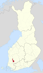
 Location of Vammala in Finland | |
| Coordinates: 61°20.5′N 022°54.5′E / 61.3417°N 22.9083°E | |
| Country | Finland |
| Region | Pirkanmaa |
| Sub-region | South Western Pirkanmaa sub-region |
| Charter | 1907 |
| Consolidated | 2009 |
| Area | |
| • Total | 876 km2 (338 sq mi) |
| • Land | 803.87 km2 (310.38 sq mi) |
| • Water | 72.13 km2 (27.85 sq mi) |
| Population (2008-12-31)[2] | |
| • Total | 16,635 |
| • Density | 19/km2 (49/sq mi) |
| Population by age | |
| • 0 to 14 | 16.8% |
| • 15 to 64 | 61.6% |
| • 65 or older | 21.6% |
| Time zone | UTC+2 (EET) |
| • Summer (DST) | UTC+3 (EEST) |
Vammala is a former town and municipality of southwestern Finland, chartered in 1907. On 1 January 2009, Vammala was consolidated with the municipalities of Mouhijärvi and Äetsä, to form a new city named Sastamala.
Geography
[edit]Vammala was located in the southwest Pirkanmaa region, and was part of the former (1997 to 2010) province of Western Finland.
- Demographics
The municipality had a population of 16,635 (31 December 2008)[2] and covered a land area of 803.87 square kilometres (310.38 sq mi).[1] The population density was 20.29 inhabitants per square kilometre (52.6/sq mi).
The municipality was unilingually Finnish.

See also
[edit]References
[edit]- ^ a b "Area by municipality as of 1 January 2008" (PDF) (in Finnish and Swedish). Land Survey of Finland. Archived from the original (PDF) on 2011-08-07. Retrieved 13 April 2010.
- ^ a b "Population by municipality as of 31 December 2008". Population Information System (in Finnish and Swedish). Population Register Center of Finland. Archived from the original on 2010-12-02. Retrieved 13 April 2010.
External links
[edit]Wikimedia Commons has media related to Vammala.


