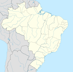
Vargeão Dome
| Vargeão Dome | |
|---|---|
 Vargeão Dome - Landsat | |
| Impact crater/structure | |
| Confidence | Confirmed |
| Diameter | 12 km (7.5 mi) |
| Depth | 225 m (738 ft) |
| Age | 123 ± 2 Ma Early Cretaceous |
| Exposed | Yes |
| Drilled | No |
| Location | |
| Location | Paraná Basin |
| Coordinates | 26°48′54″S 52°10′12″W / 26.815°S 52.17°W |
| Country | Brazil |
| State | Santa Catarina |
| Municipality | Vargeão, Faxinal dos Guedes, Passos Maia |
Vargeão Dome is a meteorite crater in Santa Catarina State, Brazil, straddling the municipalities of Vargeão, Faxinal dos Guedes, and Passos Maia.[1]
The crater is an almost perfectly circular depression with steep walls, 12 kilometres (7.5 mi) in diameter and up to 225 metres (738 ft) deep, relative to its rim. It is of Early Cretaceous age,[2] or about 123 ± 2 Ma.[1]
The meteorite impacted on the basaltic rocks of the Serra Geral Formation (Jurassic/Cretaceous). The crater displays several concentric rings and radial faults, and an eroded central bulge. The latter consists of impact breccias and sandstones from the Botucatu/Pirambóia Formation (Cretaceous/Triassic), which have been displaced about 700 metres (2,300 ft) above their mean depth in the surrounding area. At least four post-impact lava flows have been identified between the rim and core. The impact origin of the structure is attested by the presence of shatter cones and shocked quartz grains.
Discovery and studies
[edit]
In 1978, Brazilian geologists A. Paiva Filho, C.A.V. Andrade and L.F. Scheibe [3] identified an anomalous circular structure in radar images produced by the RADAMBRASIL survey, and called it the Vargeão Dome. In the early 1980s, E. Barbour Jr. and W.A.G. Correa [4] studied the structure in detail, in the context of oil/gas surveys of the area, and proposed a volcanic/tectonic origin for the structure. In 1982, Á. P. Crósta and A. Paiva Filho identified it as an impact crater.[5] Shocked quartz was identified by M. V. Coutinho in 1987, and the occurrence of maskelynite glass was reported by J. Hachiro and others in 1993 [6]
Conservation status
[edit]The area around and inside the crater has been heavily farmed since the end of the 19th century; Vargeão's city hall is located inside the crater, near the southern rim. Nevertheless, the crater is still well-preserved. The local population is well aware of the impact origin of the structure, to the point that the town's official nickname is Meteor City.
See also
[edit]References
[edit]- ^ a b "Vargeão Dome". Earth Impact Database. Planetary and Space Science Centre University of New Brunswick Fredericton. Retrieved 2017-10-09.
- ^ Crosta, A.P.; Kazzuo-Vieira, C.; Choudhuri, A.; Schrank, A. (2005). Winge, M.; Schobbenhaus, C.; Berbert-Born, M.; Queiroz, E.T.; Campos, D.A. (eds.). "Vargeão Dome Astrobleme, State of Santa Catarina: A meteoritic impact record on volcanic rocks of the Paraná Basin" (PDF). Sítios Geológicos e Paleontológicos do Brasil. Archived from the original (PDF) on 7 January 2014. Retrieved 23 February 2005.
- ^ Paiva Filho, A.; Andrade, C.A.V. de; Scheibe, L.F. (1978). "Uma janela estratigráfica no oeste de Santa Catarina: o Domo de Vargeão". Anais do 30° Congresso Brasileiro de Geologia. Vol. 1. Sociedade Brasileira de Geologia. pp. 08–412.
- ^ Barbour Jr, E.; Corrêa, W.A.G. (1981). "Geologia da Estrutura de Vargeão, SC". PauliPetro, Consórcio CESP/IPT: 33.
{{cite journal}}: Cite journal requires|journal=(help) - ^ Paiva Fº, A.; Crósta, A.P.; Amaral, G. (1982). "Utilização de dados de sensoriamento remoto no estudo estratigráfico e estrutural da Formação Serra Geral (Sul do Brasil)". Anais do II Simpósio Brasileiro de Sensoriamento Remoto. Vol. 1. Instituto Nacional de Pesquisas Espaciais (Brazil). pp. 135–142.
- ^ Hachiro, J.; Coutinho, J.M.V.; Frascá, M.H.B. de O.; Menezes, C.M. (1993). "O astroblema de Vargeão (SC): evidências petrográficas de um crateramento criptoexplosivo por petardo extraterrestre". Atas do Simpósio Brasileiro de Geologia. Vol. 3. Sociedade Brasileira de Geologia. pp. 276–283.


